|
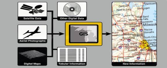
Geographical Information System by Saurabh Singh * Part - II Geographical Information System "Everything is related to everything else, but near things are more related than distant things." - Tobler's First Law of Geography Some 35,000 years ago, Cro-Magnon hunters drew pictures of the animals they hunted on the walls of caves near Lascaux, France. Associated with the animal drawings are track lines and tallies thought to depict migration routes. These early records followed the two-element structure of modern geographic information systems (GIS): a graphic file linked to an attribute database. Geographical Information System in the most simplest of words can be explained as: Previously we had paper maps, which were very colorful, which we couldn't modify. When the computer revolution came the maps were digitized and stored in digital format. These were just entities (line, circle, polygon or point) and it use not give any information, what that entity means in geographical terms. Using these digital files we can only modify easily and reproduce it quickly. We can not use them for any analysis purpose. The GIS finally arrived and made these entities intelligent. It attached a value (attribute) to these entities, with what it actually means in geographical terms.
* Contributed by - |